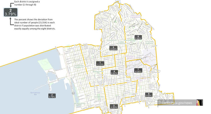
Check out and give feedback on four draft maps proposing potential boundaries for City Council Districts for the next decade. See which neighbors you'd be connected to.
These maps - drawn by an independent commission that used public input - connect different parts of Berkeley in different ways, but they each:
- create contiguous districts of similar size
- strive to keep communities of interest together
- use major streets as boundaries when possible
- eliminate prior boundaries drawn to preserve a prior councilmember's residence
- include one compact student district
The four maps were drawn at the direction of the Independent Redistricting Commission, a body created by Berkeley voters to create more politically neutral boundaries.
These four maps reflect different possibilities. Check them out online or in person. Give feedback via email, mail, or at an upcoming Zoom meeting.
See different proposed maps
Each proposed map uses different principles.
The Orange Map has a high level of continuity with the existing council district boundaries. This map maintains general consistency for Districts 3 - 8, with significant changes to Districts 1 and 2 in West Berkeley.
The Maroon Map creates a draft map that shows variations on two student-focused districts. This map shows West Berkeley in its current configuration of two districts.
The Blue Map shows, per Commission direction, variations on two student-focused districts and a map with a north to south orientation for a single West Berkeley District.
The Amber Map responds to the direction of the Independent Redistricting Commission to create a draft map that has a high level of continuity with the existing council district boundaries and includes changes only as needed to meet the six universal map criteria.
You can also see printed draft maps:
- Large printed maps: Central Branch Library and South Berkeley Senior Center
- Mid-size maps: each community center and other branch libraries
Review the submitted City Council district maps
When reviewing maps, keep these general requirements in mind:
- Is the population in each district nearly equal?
- Do the boundaries keep neighborhoods together?
- Are communities with common interests kept together in one district?
Give input at upcoming meetings or via email or mail
You can give feedback at meetings, in writing, or virtually.
Four virtual public meetings are scheduled to get your input before adopting the final map.
- Thursday, January 27, 6:00 pm: Input on draft maps
- Zoom: https://us02web.zoom.us/j/82263782343
- To join by phone: Dial 1-877-853-5257 (Toll-free) and enter Meeting ID: 822 6378 2343
- Thursday, February 17, 6:00pm: Input on draft maps
- Monday, February 28, 6:00 pm: Input on final map
- Wednesday, March 16, 6:00 pm: Adoption of the final map
More meetings may be added to the schedule, so please join our redistricting mailing list to stay connected.
Share comments by:
- Email: redistricting@cityofberkeley.info
- Mail: City Clerk Department, 2180 Milvia Street, 1st Floor, Berkeley, CA 94704
You can also provide feedback about keeping communities together in the same voting district using our online form or via a downloadable PDF that you can email or mail to the City Clerk Department.
More about redistricting
City Council districts are redrawn every 10 years, adjusting to population changes identified in the Census. Previously, district boundaries were decided by the City Council. Now, an independent commission made up of community members is deciding the map boundaries.
Your feedback will help ensure that maps are drawn with many perspectives. Share your thoughts and help ensure fair districts for all.
Links
- City of Berkeley Independent Redistricting Commission
- Communities of Interest Online Form
- Communities of Interest downloadable ( English/ Español)
- Draft online maps: Orange; Maroon; Blue; Amber
Media Contact
Strategic Plan Goal