
Fire Weather and Evacuation
Check and sign up for emergency alerts
Get real-time wildfire evacuation alerts with the City’s tools:
- Berkeley Emergency Map: See current evacuation orders on the emergency map and download the Genasys Protect app to get real-time alerts on your phone
- AC Alert (Alameda County Alert): View recent messages and sign up to receive detailed alerts via phone and email
Learn more about official alerting tools on our Emergency Notifications page.
Make a plan to evacuate faster
All Berkeley residents should make a general evacuation plan using our Evacuation Planning Worksheets. Decide what you will pack, where you will go, and two evacuation routes you could use to leave your neighborhood.
Berkeley hillside neighborhoods face the City’s highest wildfire and evacuation risk. Hills residents should use Evacuation Planning Worksheets to make specific plans for fire weather and wildfire evacuation.
know when fire danger is highest
Residents subscribed to AC Alert will receive two types of fire weather alerts when strong winds and dry conditions increase wildfire risk.
- Red Flag Warning – Issued by the National Weather Service when fire weather is in the forecast in the East Bay.
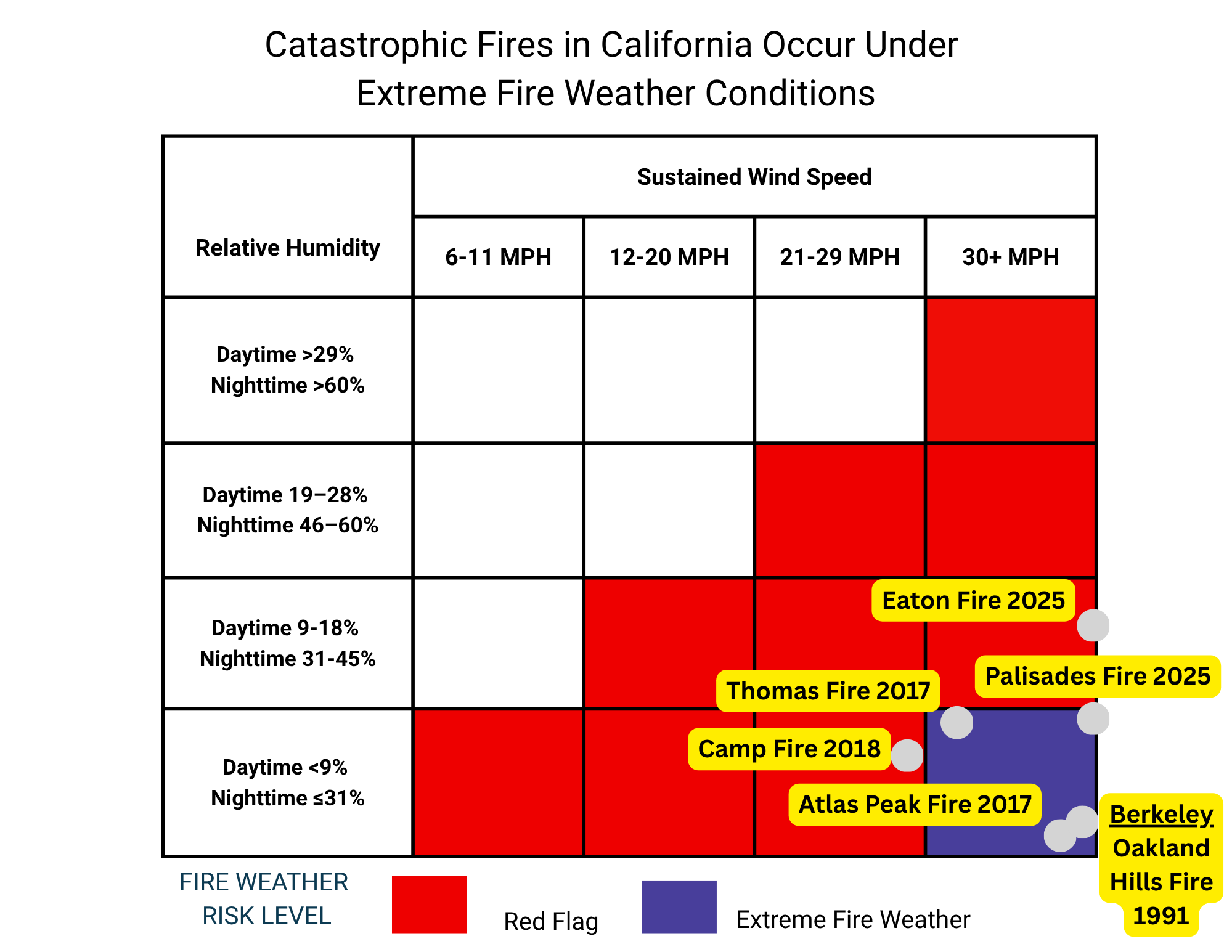
- Extreme Fire Weather – Issued by the Berkeley Fire Department when wildfire danger is at its highest. These alerts are rare and used only when there is strong confidence that dangerous fire weather will affect Berkeley. If a fire starts during Extreme Fire Weather, it may spread faster than people can safely evacuate from the Berkeley hills.
The chart below shows approximate wind and humidity levels during Red Flag Warnings and Extreme Fire Weather. The Berkeley Fire Department declares Extreme Fire Weather when wildfire risk is at its highest. California's most deadly wildfires happen under these conditions, including the 1991 Oakland/Berkeley Hills Fire.
Actions for hills residents during red flag warnings
In a Red Flag Warning, firefighters may not be able to quickly stop a fire. Hills residents should be ready for a fire evacuation:
- Sign up for AC Alert and download the Genasys Protect App
- Keep your phone on and with you to receive alerts
- Back your car into your driveway
- Keep a go-bag by the door
- Check in with neighbors to help each other
Actions for hills residents During extreme Fire Weather
In Extreme Fire Weather, all Hills residents should take the Red Flag Warning steps listed above. Hills residents should also pack a vehicle. If a fire ignites, you will be able to leave more quickly.
Upper Berkeley Hills and Panoramic Hill residents should leave before a fire starts
Residents of the Upper Berkeley Hills and Panoramic Hill have the highest wildfire and evacuation risk. These residents are closest to wildland areas and have the longest path out of the hills. A fire that ignites during Extreme Fire Weather may spread faster than some Berkeley Hills residents can safely evacuate.
During Extreme Fire Weather, these residents should leave early before a fire starts and stay elsewhere.
The Upper Berkeley Hills and Panoramic Hill are considered Leave Early Zones: BER-006, BER-007, BER-008, BER-015, BER-016, BER-017, BER-030, BER-031, BER-057, BER-058.
Visit the Berkeley Emergency Map and enter your address to see if you live in a Leave Early Zone.
Other Hills residents should also consider leaving early
The Berkeley Fire Department recommends that residents in any part of the Berkeley Hills leave early during Extreme Fire Weather if any of the following apply:
- Your street has only one way in or out
- Your household needs help from people outside your neighborhood to pack and leave
- Your household would plan to evacuate the Berkeley hills on bike or foot
- Your household prefers not to be caught in an emergency evacuation
Learn more
Sign up for training to get help with your fire weather plans on our Eventbrite page.
Learn more about Berkeley’s evacuation research using the Evacuation StoryMaps.
News