PROJECT LOCATION
View the project map for a detailed view of treatment areas.
- Phase 1: Wildcat Canyon Road and Grizzly Peak Boulevard
- Phase 2: Streets between Wildcat Canyon and Grizzly Peak Boulevard, including Vistamont Ave, Creston Road, Middlefield Road, and Summit Road
- Phase 3: Park Hills Road, Woodside Road, the Crescent, Shasta Road, Campus Drive, La Loma Ave, Cedar Street, Marin Ave, and Eunice Street, and others
- Phase 4: Euclid Ave, Spruce Street
- Phase 5: Arlington Ave, Del Norte Street, Hopkins Street, Marin Ave (lower), Sutter Street, and others
WHAT'S HAPPENING
The Grizzly Peak Vegetation Management Project aims to reduce fire risk, improve hillside wildfire evacuation routes, and create safer conditions for the community along Grizzly Peak Boulevard.
By removing dangerous plants and thinning vegetation in wildlands along roadways next to Grizzly Peak Blvd., we create a fuel break—an area with less flammable material that helps to slow the spread of wildfire and gives people more time to evacuate safely.
Stay up to date with this project by subscribing to the Grizzly Peak Project newsletter.
Project overview
The vegetation management project was funded by CAL FIRE’s Wildfire Prevention Grants Program. The Berkeley Fire Department will complete this work in partnership East Bay Municipal Utility District (EBMUD), UC Berkeley, and East Bay Regional Park District (EBRPD) to remove hazardous vegetation within 10 feet of the roadway along Grizzly Peak Boulevard.
Once this project is complete, over 110 acres spanning more than 40 miles of road will be cleared. Mitigating the vegetation on Grizzly Peak’s wildfire pathways follows the fire code guidelines that state flammable plants should be removed from both sides of the road.
Most native plants can remain in the area but may be trimmed or thinned out if they are large and dense. The goal is to remove the most dangerous vegetation while protecting the natural environment. To ensure the project does not disrupt the local habitat, biological monitors will also continuously survey wildlife and nesting birds in the area.
Project timeline
The Grizzly Peak vegetation management project occurs in several phases to ensure the work is safe, effective, and done with care for the environment.
Planning and Preparation
We concluded the phase which identified the most hazardous areas to mitigate, working with partners like EBMUD, UC Berkeley, and EBRPD. We’re also reaching out to the community to share information and gather feedback.
Vegetation Removal and Thinning
In 2025, crews began removing dead or dying plants and thinning dense vegetation along roadways. Generally, native, non-hazardous vegetation will not be removed, but it will be pruned or reduced in density. The goal is to reduce wildfire risk and create a fuel break that slows the spread of fire and keeps evacuation routes clear.
Maintenance and Monitoring
After the initial work is complete, the area will be monitored and maintained to help protect the area long-term.
Images
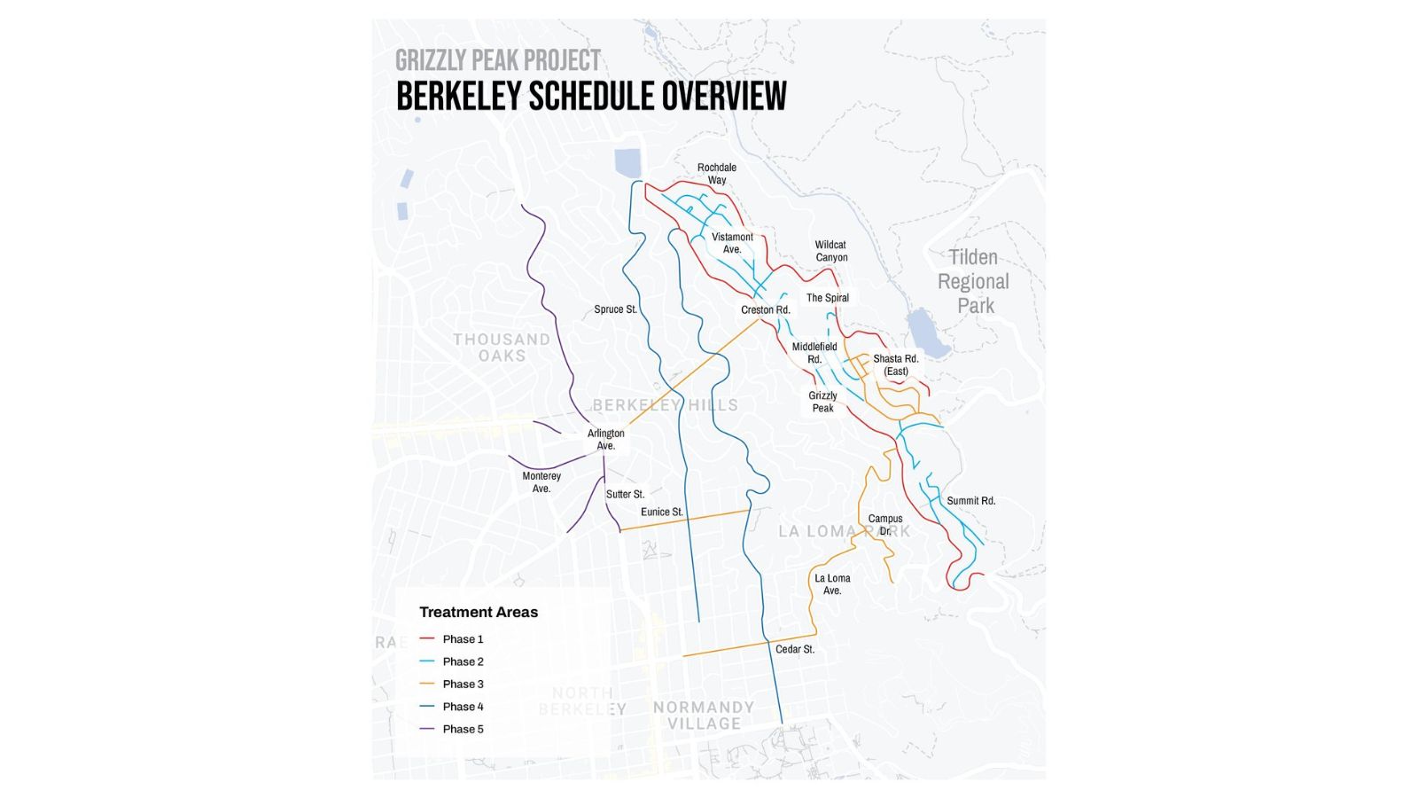
Grizzly Peak Treatment Phase Map
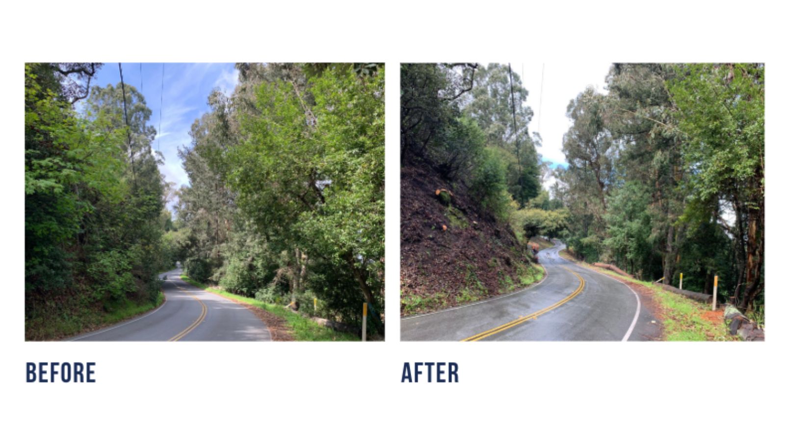
Grizzly Peak Blvd., before and after pictures of part of the treatment area.